Mach Loop - UK Low Level Flying by Military aircraft - Mach Loop Wales - MachLoop.co.uk

Cad West & Cad East

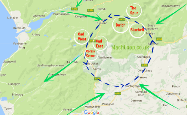
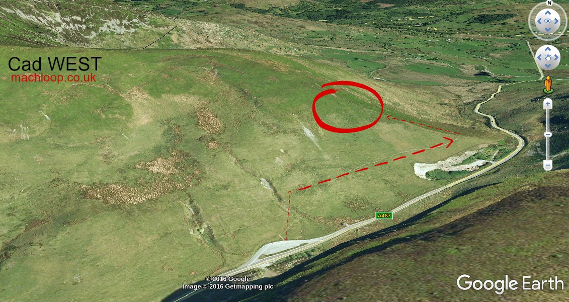
Cad West, in the Mach Loop, is a great location if you want a ‘topside’ or ‘level-pass’ view of aircraft. You also get a decent amount of time to prepare following the initial shout of “incoming!”, as the aircraft approach from your left. If you are lucky, they will sometimes take a left in to Corris Corner, potentially giving you the opportunity for a second pass. There is plenty of room for parking, with a steadily advancing climb as you make your way up the hillside.

Cad West

Latitude: 52:42:31N
Longitude: 3:50:42W
Approximate climb: 300 feet
Car park distance: Half a mile
Nearest Post Code: LL40 2SH

Cad West, mach loop

Cad East

Latitude: 52:42:13N
Longitude: 3:50:38W
Approximate climb: 400 feet
Car park distance: One mile
Nearest Post Code: L40 2SH

Cad East, in the Mach Loop, is a the place to visit if you want a ‘topside’ view of aircraft, stunning views as far as Bala and Mount Snowdon on a clear day. The aircraft pass from your right, with plenty of time to prepare. The ascent is relatively lengthy (in Mach loop viewing location terms), but it is worth the effort.

Cad East, mach loop<img src=

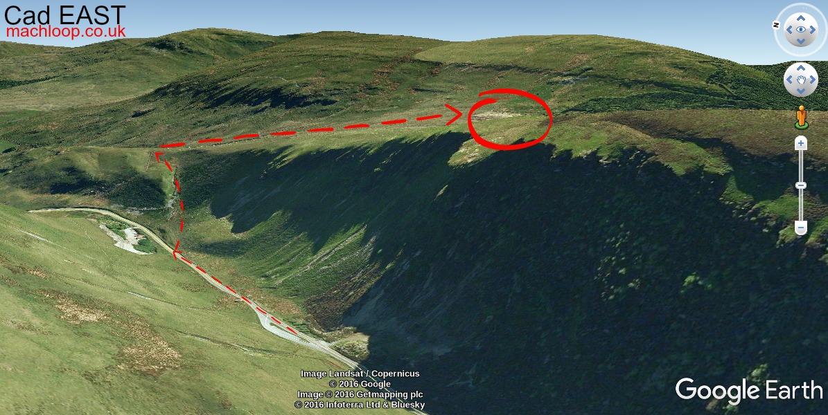
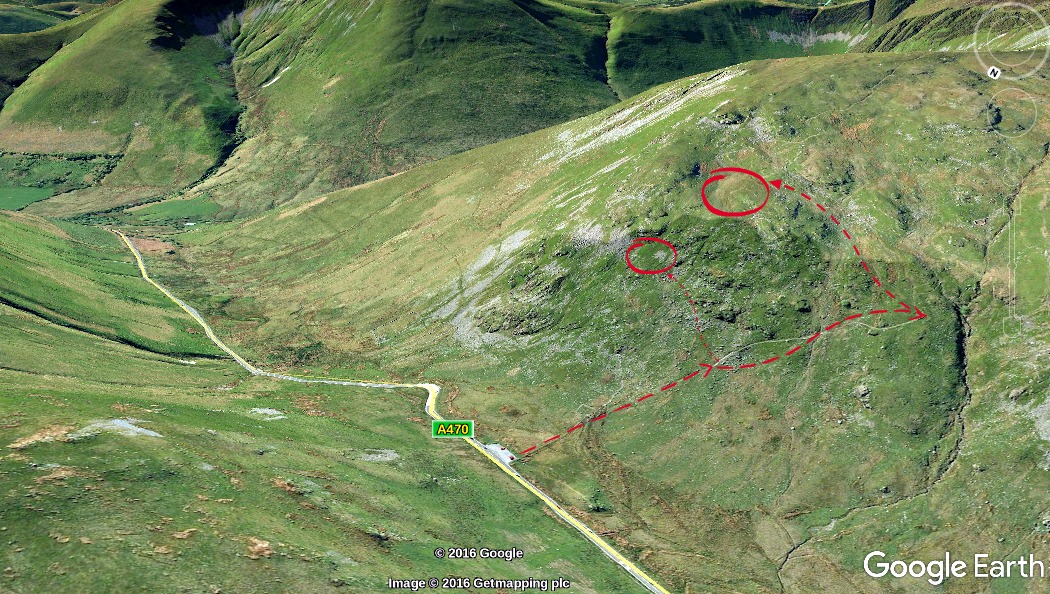
This images above are intended purely as a rough guide to finding your way to Cad West and cad East. The arrows provide you a general flow for the climb – be sure to take care and follow the safest route for you.

Photos taken from Cad West or Cad East: Coming soon!
If you would like to share your photographs taken from this location, please drop us an email to photos@machloop.co.uk. We will gladly provide acknowledgment and a link to your portfolio for any that are used.

Respect and consideration!

Please remember that the majority of these locations fall on privately owned land, so take care if crossing fences or gates – and please do not leave any litter.
The same should also be said to parking your vehicle in a considerate and unobstructive manner.

Finding the Mach Loop

Map of Mach Loop

If you are planning to visit the Mach loop and are wondering how to find it, we have compiled a list of the most popular viewing locations that include useful information such as lat/long, nearest post code and car parking. You can find the mach loop guides in the menu under ‘Viewing locations’.

Photos taken from Mach Loop: Coming soon!
If you would like to share your photographs taken from this location, please drop us an email to photos@machloop.co.uk. We will gladly provide acknowledgment and a link to your portfolio for any that are used.

Please remember that the majority of these locations fall on privately owned land, so take care if crossing fences or gates – and please do not leave any litter.
The same should also be said to parking your vehicle in a considerate and unobstructive manner.

Bwlch

Bwlch, in the Mach Loop, is a great location if you want a ‘topside’ or ‘level-pass’ view of aircraft. You also get a few seconds heads-up, as the aircraft approach from your right.

This image above is intended purely as a rough guide to finding your way to Bwlch Middle and Top Ledge. The arrows provide you a general flow for the climb – be sure to take care and follow the safest route for you.

Latitude : 52:44:06NLongitude : 3:46:30W

Approximate climb:  Top ledge, around 400 feet. Middle Ledge, roughly 200 feet
Car park distance: Under half a mile
Nearest Post Code:  LL40 2SH

Photos taken from Bwlch: Coming soon!
If you would like to share your photographs taken from this location, please drop us an email to photos@machloop.co.uk. We will gladly provide acknowledgment and a link to your portfolio for any that are used.

Respect and consideration!

Please remember that the majority of these locations fall on privately owned land, so take care if crossing fences or gates – and please do not leave any litter.
The same should also be said to parking your vehicle in a considerate and unobstructive manner.